
SpatialBinnedPointData
SpatialBinnedPointData[{reg1val1,reg2val2,…}]
represents values vali associated with disjoint regions regi.
SpatialBinnedPointData[{reg1,reg2,…}{val1,val2,…}]
gives the same result.
SpatialBinnedPointData[…,reg]
gives the overall observation region reg.
Details and Options
- SpatialBinnedPointData makes it possible to work with aggregated spatial point data, as is often reported reported in census information, infectious disease data and crime data.
-
- SpatialBinnedPointData can be used like individual point data for many kinds of computations by simulating it as InhomogeneousPoissonPointProcess.
- The regions regi and reg can be either geometric or geographic regions, but should all be of the same type.
- The regions regi and reg should be parameter-free, fully dimensional and bounded, as tested by SpatialObservationRegionQ.
- The regions regi are assumed to be disjoint and contained within the observation region reg.
- The values vali can be scalars or vectors of any dimension, but must all be of equal dimensionality.
- The integer values vali are understood to correspond to point count per region and such SpatialBinnedPointData can be treated as an InhomogeneousPoissonPointProcess with a piecewise-constant intensify function.
- Basic properties include:
-
"Bins" a list of binning regions "BinCount" number of bins "BinMeasures" measures of the binning regions "Dimension" dimensionality of the binning regions "Values" values for each binning region "ConfigurationCount" number of binned observations over the same binning "ObservationRegion" global observation region - SpatialBinnedPointData can be used in functions such as PointProcessFitTest and SpatialRandomnessTest.
Examples
open all close allBasic Examples (2)
Create SpatialBinnedPointData using the geographic entities to specify bins:
(# -> CountryData[#, "Population"])& /@ CountryData["SouthAmerica"]SpatialBinnedPointData[%]Visualize the binned population density:
%["DensityVisualization"]Create SpatialBinnedPointData using the geographic entities to specify bins:
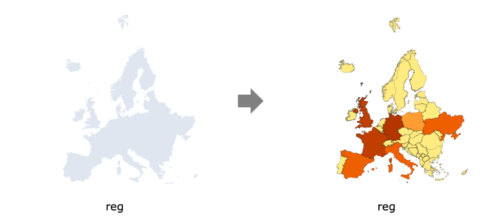
countries = Entity["GeographicRegion", "Europe"][EntityProperty["GeographicRegion", "Countries"]];Number of airports per entity:
airports = CountryData[#, "Airports"]& /@ countries;data = SpatialBinnedPointData[countries -> airports]Visualize the airport density with bin specified by country polygons:
data["DensityVisualization"]Scope (4)
Create SpatialBinnedPointData from quadrant observations:
bins = Flatten@Table[Rectangle[{i, j}, {i + 1, j + 1}], {i, 0, 10}, {j, 0, 10}];Graphics[{FaceForm[ColorData[97, 1]], EdgeForm[Black], bins}]vals = RandomInteger[10, Length[bins]];Use bins and values to create SpatialBinnedPointData:
data = SpatialBinnedPointData[bins -> vals]Create a corresponding intensity function:
int = HistogramPointDensity[data]int["DensityVisualization"]Test for complete spatial randomness:
SpatialRandomnessTest[data, "TestConclusion"]Use a list of regions as bins:
SeedRandom[2];
regions = Disk[#, 2]& /@ RandomInteger[{-10, 10}, {5, 2}];sp = SpatialPointData[RandomReal[{-10, 10}, {100, 2}], Rectangle[{-10, -10}, {10, 10}]];sb = SpatialBinnedPointData[sp, regions]%["Values"]regplot = Region[RegionUnion@regions, Axes -> True]Define a point process with intensity defined by the binned point data:
proc = InhomogeneousPoissonPointProcess[HistogramPointDensity[sb], 2]Simulate the point collection:
sample = RandomPointConfiguration[proc, RegionUnion@regions];Show[regplot, ListPlot[sample, PlotStyle -> Black]]Input the counts and bins manually:
SeedRandom[2];
regions = Disk[#, 2]& /@ RandomReal[{-10, 10}, {5, 2}];ns = RandomInteger[10, 5];SpatialBinnedPointData[ns, regions]Test for complete spatial randomness:
sb = SpatialBinnedPointData[{{5, 11, 10, 5, 4, 11, 7, 7, 5, 10, 11, 9, 5}},
 SpatialAnalysis`RegionPartition["AggregatedMeshRegion",
  MeshRegion[{{-0.024328249475753738, 0.11959962427071952}, {-0.016453346499402777,
     0.5405894326667253}, {1.0041 ...     {0.7272568409884758, 0.6785813396468685}, {0.908403190951901, 0.13905862821805207},
     {0.920862437803657, 0.5360317046598139}, {0.8319208691069746, 0.8619734273549864}}], {13, 2}],
Association["ConfigurationCount" -> 1, "GeoQ" -> False]];SpatialRandomnessTest[sb]Properties & Relations (1)
data = SpatialBinnedPointData[{{9, 7, 7, 4, 3, 7, 6, 6, 15, 9, 8, 9, 10}},
 SpatialAnalysis`RegionPartition[{"AggregatedMeshRegion", "Geo"},
  MeshRegion[{{-0.008726700812770683, -0.008682821301233276},
    {0.008726700812770686, -0.008682821301233276} ... 398}}],
   "Projection" -> {"LambertAzimuthal", "Centering" ->
      GeoPosition[{0.4975047854908847, 0.4999999999999999}]}, "Datum" -> "ITRF00",
"MeasureUnit" -> "Meters"^2], {13, 2}], Association["ConfigurationCount" -> 1, "GeoQ" -> True]];data["Properties"]Text
Wolfram Research (2020), SpatialBinnedPointData, Wolfram Language function, https://reference.wolfram.com/language/ref/SpatialBinnedPointData.html.
CMS
Wolfram Language. 2020. "SpatialBinnedPointData." Wolfram Language & System Documentation Center. Wolfram Research. https://reference.wolfram.com/language/ref/SpatialBinnedPointData.html.
APA
Wolfram Language. (2020). SpatialBinnedPointData. Wolfram Language & System Documentation Center. Retrieved from https://reference.wolfram.com/language/ref/SpatialBinnedPointData.html